map-icon
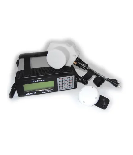
New Iraq Enterprises, Quetta, Balochistan 87300
phone-icon+92 314 8000013
Menu
  • Home
  • Shop
    • Surveying Equipments

      Hydrographic Surveying Equipments

      GEM GSM-19 Cost Effective and High Precision Overhauser Magnetometer

      Dynamic gravity Systems AT1-L

      GeoGis

      Stonex Digital Level D1

      M1 Laser Distance Meter

      R35/R35LR Total Station

      S980 GNSS Receiver

      Read more

      Stonex Digital Level D1

      Stonex Surveying Equipments
      Read more

      S980 GNSS Receiver

      Stonex Surveying Equipments
    • Hydrographic Surveying Equipments

      Hydrographic Surveying Equipments

      GEM GSM-19 Cost Effective and High Precision Overhauser Magnetometer

      Dynamic gravity Systems AT1-L

      GeoGis

      Stonex Digital Level D1

      M1 Laser Distance Meter

      R35/R35LR Total Station

      S980 GNSS Receiver

      Read more

      Stonex Digital Level D1

      Stonex Surveying Equipments
      Read more

      S980 GNSS Receiver

      Stonex Surveying Equipments
      STORES
      Find retail locations
      CUSTOMER CARE

      For All Your Questions

    • Marble

      Marbles

      Limestone Rock Slabs

      Marble Onyx

      Brookite Rock

      Agate Rock

      Fluorite Rock

      Gypsum Rock

      Imperial Jupiter -Tramonix

      Antimony Rock

      Manganese Rock

      Barite Rock

      Copper Rock

      Lead Rock

      Zinc Rock

      Chromite Rock

      Iron Rock

      Granite Rock

      Molybdenum

      Sulfur Rock

      Barite Rock

      Manganese Rock

      Read more

      Sulfur Rock

      Marble
      Read more

      Agate Rock

      Marble
    • Copper
    • Mining Projects
    • Speed Checking Systems

      Hydrographic Surveying Equipments

      GEM GSM-19 Cost Effective and High Precision Overhauser Magnetometer

      Dynamic gravity Systems AT1-L

      GeoGis

      Stonex Digital Level D1

      M1 Laser Distance Meter

      R35/R35LR Total Station

      S980 GNSS Receiver

      Read more

      Stonex Digital Level D1

      Stonex Surveying Equipments
      Read more

      S980 GNSS Receiver

      Stonex Surveying Equipments
    • Gpr and Pave Testing
    • Laser land levelers
    • Law Inforcement Equipments
    • Furniture Equipments
    • It Equipments
  • About us
  • Support and Services
  • Dealer Locator
  • Contact us
map-iconToghi Road Quetta
phone-icon+92 314 8000013
Click to enlarge
Home Gpr and Pave Testing NOGGIN Complete GPR
GEM GSM-19 Cost Effective and High Precision Overhauser Magnetometer
Back to products
FINDAR® Locate buried evidence

NOGGIN Complete GPR

NOGGIN® GPR systems have been recognized by leading researchers as providing the highest quality GPR data in the world.  They are also built to perform in the most demanding conditions around the globe.

Adaptable, proven GPR for any application

Available in four center frequencies and four standard configurations, NOGGIN® systems can collect data in any environment for any application. NOGGIN® span the depths and resolutions required for subsurface investigations. Choose the combination of center frequency and configuration best suited to your application and terrain.

Category: Gpr and Pave Testing
Share:
  • Description
  • Shipping & Delivery
Description

Description

Wi-Fi mini-reports Email a report of line, depth slice or map view data to your customers or colleagues.
Depth slicing Collect grids of data and view depth slices right in the field.
Map view Using external GPS, display a plan map view of survey path, grids, field interpretations and flags.
Field interpretations Add color-coded interpretations and field flags with the touch of a finger.
Optional GPS Integrated GPS for post-processing and export to Google Earth™, CAD drawings & GIS databases.
Multi-language English, French, German, Spanish, Japanese, Simplified Chinese, Farsi, Russian, Arabic.

The data collection software on the DVL 500 Noggins have default settings to get to work quickly; for line surveys just set the desired depth and start collecting.
For grid collection, the GPR operator sets the grid size and line spacing. The screen prompts the user to collect each line until the grid is complete. It is easy to work around obstructions, skip lines or recollect lines if required.
Once the grid is finished (or any time after at least 3 lines have been collected), the grid data can be processed into depth slices (right in the field!).

For users involved in unusual projects, Noggins also have custom settings to collect data with extreme values:

• Depths to 200 meters (320 m in ice)
• Triggering options include Odometer, Button and Free-Run modes
• Free Run in Time or Free-Run with Speed to collect data on water, snow or ice
• Grids up to 250 x 250m in size
• Zig-zag grid collection pattern
• Step Sizes from 5 millimeters to 5 meters

Create impressive deliverables easily with EKKO_Project™ software.

After data collection is finished, transfer the data to your computer and organize, edit, process and plot your GPR data with EKKO_Project™. See your data in seconds – spend your time understanding the data, not importing and integrating ancillary information.
EKKO_Project™’s reporting capability outputs interpretations and other information into PDF, spreadsheet (csv), Google Earth™ (kmz) and CAD (dxf) files.


Mode of Operation:

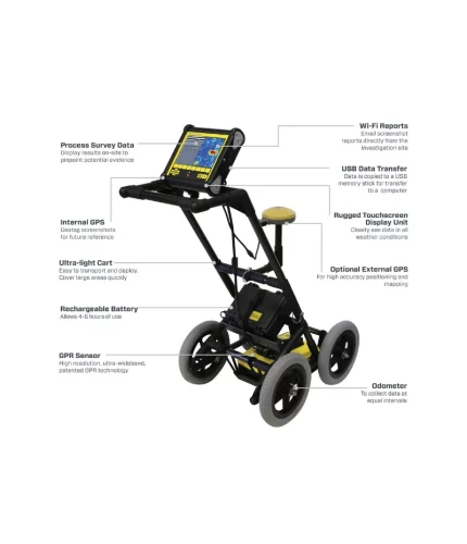
The SmartCart® provides a self-contained, mobile platform for transporting the NOGGIN® and DVL for fast, efficient data acquisition over smooth to moderately rough terrain.

SmartCart® features:

  • A wheel odometer to trigger data acquisition at default or user-defined intervals (step size) to provide uniform data coverage.
  • A bi-directional odometer that triggers data acquisition in one direction and, in the other direction, provides a back-up arrow to easily pinpoint the location of objects found on the survey line.
  • Sensors & Software’s unique DynaQ® feature automatically adjusts data acquisition rates to the survey speed; providing dynamic stacking to maximize data quality.

Options:

  • GPS to provide geo-referenced coordinates linked to the data
  • Brackets to quickly swap between the NOGGIN® 100, 250, 500 and 1000 sensors

Supported Sensors:

The SmartCart™ supports all NOGGIN® sensors.

Mode of Operation:

The NOGGIN® SmartTow™ configuration is designed for hand-tow surveying over smooth to rough terrain such as grassy, brush covered or rocky surfaces. But don’t worry about damaging your NOGGIN® by dragging it around on rough surfaces – all Noggins have a durable skid plate on the bottom to smoothly slide across any surface and maintain ground-coupling for maximum signal penetration.

SmartTow™ features:

  • A wheel odometer to trigger data acquisition at default or user-defined intervals (step size) to provide uniform data coverage.
  • A bi-directional odometer that triggers data acquisition in one direction and, in the other direction, provides a back-up arrow to easily pinpoint the location of objects found on the survey line.
  • Sensors & Software’s unique DynaQ® feature automatically adjusts data acquisition rates to the survey speed; providing dynamic stacking to maximize data quality.

Options:

  • GPS to provide geo-referenced coordinates linked to the data.
  • Longer cables to enable the DVL to be set in a fixed position while the GPR sensor is moved.
  • Batteries of different sizes and capacities depending on field time or portability requirements
  • Brackets to quickly swap between the NOGGIN® 100, 250, 500 and 1000 systems.

Supported Sensors:

The SmartTow™ supports all NOGGIN® sensors.

SmartChariot™


Mode of Operation:

The SmartChariot™ provides vehicle-towed deployment of NOGGIN® 250, 500 or 1000 systems. It is ideal for surveys covering large, smooth, open areas that can be performed using a vehicle: roads, highway sections and bridges needing quick assessment, large parking lots, parking garages, and open fields such as golf courses and parks.
The SmartChariot™ attaches to a common trailer hitch on any vehicle: cars, trucks and vans, but also ATV’s (all-terrain vehicles), tractors and even bicycles and motorcycles can be used.

SmartChariot™ features:

  • A wheel odometer to trigger data acquisition at default or user-defined intervals (step size) to provide uniform data coverage.
  • Sensors & Software’s unique DynaQ® feature automatically adjusts data acquisition rates to the survey speed; providing dynamic stacking to maximize data quality.
  • A mount for a GPS receiver (GPS optional).
  • Brackets to quickly swap between the NOGGIN® 250, 500 and 1000 systems.
  • The ability to deploy two Noggins simultaneously: a NOGGIN® 500 and a NOGGIN® 1000.

Options:

The following optional items are available to customize the system for your needs.

  • GPS to provide geo-referenced coordinates linked to the data
  • Smaller or longer-life batteries depending on the time duration of measurements or portability requirements

Supported Sensors:

The SmartChariot™ supports the NOGGIN® 250, 500 or 1000 sensors.

Shipping & Delivery

MAECENAS IACULIS

Vestibulum curae torquent diam diam commodo parturient penatibus nunc dui adipiscing convallis bulum parturient suspendisse parturient a.Parturient in parturient scelerisque nibh lectus quam a natoque adipiscing a vestibulum hendrerit et pharetra fames nunc natoque dui.

ADIPISCING CONVALLIS BULUM

  • Vestibulum penatibus nunc dui adipiscing convallis bulum parturient suspendisse.
  • Abitur parturient praesent lectus quam a natoque adipiscing a vestibulum hendre.
  • Diam parturient dictumst parturient scelerisque nibh lectus.

Scelerisque adipiscing bibendum sem vestibulum et in a a a purus lectus faucibus lobortis tincidunt purus lectus nisl class eros.Condimentum a et ullamcorper dictumst mus et tristique elementum nam inceptos hac parturient scelerisque vestibulum amet elit ut volutpat.

Related products

FINDAR® Locate buried evidence

Gpr and Pave Testing
Read more

FINDAR® uses ground penetrating radar (GPR) technology to enable law enforcement to quickly and effectively search for evidence buried under the ground.

  The advantage of GPR compared to other commonly-used subsurface search technologies, such as metal detectors, is its ability to detect both metallic and non-metallic objects. FINDAR can locate:
  • Clandestine graves
  • Drugs or money buried in metal or plastic containers
  • Buried weapons and ammunition stashes

Benefits of FINDAR®

  • Locate evidence in real time
  • Convenient and intuitive to use with minimal training
  • Locate buried evidence on a variety of terrains and make decisions on-site.
  • The intuitive user interface guides investigators through a systematic grid search
  • Generate 3D images on-site in seconds pinpointing the position and depth of potential evidence
  • Compact and portable system that fits into a single hand-carried shipping case.
  • Transfer data and captured images to a PC and integrate images into reports.
  • Archive data and screenshots in a single file for future reference
    We deal in all types of Printing & General Order Suppliers
    • Toghi Road Quetta
    • Phone: +92 314 8000013
    • Sales@newiraqenterprises.com/
    Our Offices
    • Islamabad
    • Lahore
    • Dubai
    USEFUL LINKS
    • Privacy Policy
    • Returns
    • Terms & Conditions
    • Contact Us
    • Latest News
    • Our Sitemap
    © 2023 New Iraq Enterprises. All Rights Reserved.
    • Home
    • Shop
      • Surveying Equipments
      • Hydrographic Surveying Equipments
      • Marble
      • Copper
      • Mining Projects
      • Speed Checking Systems
      • Gpr and Pave Testing
      • Laser land levelers
      • Law Inforcement Equipments
      • Furniture Equipments
      • It Equipments
    • About us
    • Support and Services
    • Dealer Locator
    • Contact us
    × How can I help you?